Cartopological Maps
The cartopological maps in the Turning the Tide project capture cities not from above, but from within. By living in these places, observing daily life, and engaging with inhabitants, Marlies Vermeulen and Remy Kroese (Dear Hunter) explore how water and climate shape both landscape and society. Each map is a situated record of questions, encounters, and impressions: never complete or objective, but always rooted in the lived experience of being there.
Together, the four maps form the Turning the Tide Atlas, a guide to rethinking the relationship between water, climate, and urban life.
© Remy Kroese
Introduction for the Gdańsk map
In Gdańsk, water is everywhere: the Baltic Sea, murmuring rivers, centuries-old locks, canals, and reclaimed land. Yet its presence can feel so self-evident that it goes unremarked. This map explores that quiet intimacy; how the city lives with and from water, and how climate change is slowly reshaping this balance. From shipyards to sandy beaches, from historic fortifications to floating hotel rooms, Gdańsk’s identity is inseparable from its waters. Our cartopological research here asks: what happens when the obvious is questioned, and the familiar made visible again?
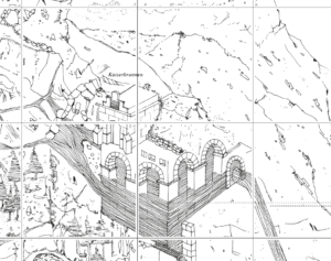
Introduction for the Vienna map
Vienna takes great pride in its drinking water: for over 150 years, crystal-clear spring water has been flowing from the mountains straight into the city. This map follows that journey, through valleys and aqueducts, to springs and the people who maintain them with skill and dedication. Yet it also raises questions: how sustainable is this celebrated system as Vienna grows? Are the sources truly inexhaustible, and where does groundwater fit into the picture?
The map challenges the strong perceptions of various water sources. Depending on how you turn it, the map can be read in two ways: what seems to be valley might also be mountain, and what is hidden beneath the surface is revealed as an equally vital source. Our cartopological research in Vienna thus explores not only the infrastructure and expertise behind the water system, but also the cultural perceptions that shape how people value and understand their most essential resource.
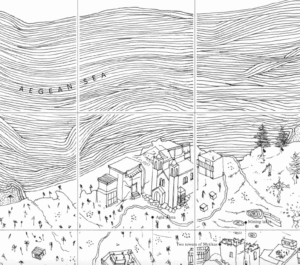
Introduction for the Evia map
On Evia, the traces of recent forest fires and floods are everywhere, yet they reveal more than natural disasters alone. This map explores the island through two contrasting logics: that of the bricoleur, rooted in cycles, resilience, and local knowledge, and that of the engineer, imposing abstract plans and large-scale infrastructures from above. Between these worlds lies a struggle over what “progress” means, and for whom. Our cartopological research on Evia maps not only destruction and reconstruction, but also mistrust, resistance, and the everyday practices that quietly sustain life on the island.
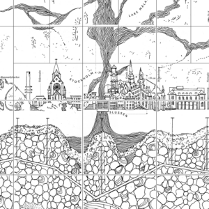
Introduction for the Stockholm map
The Dear Hunter Stockholm Map examines Stockholm’s landscape as a record of long-term ecological processes and increasingly short-term human decisions. By placing ancient myths, Indigenous knowledge, and geological time alongside contemporary infrastructure, extraction, and climate adaptation measures, the map reveals tensions between care, control, and exploitation. It questions whether technical fixes alone can secure the future of land and water. Instead, the map suggests that enduring responses to climate change may require rethinking how humans imagine their place within living landscapes.